

My go-to topographical map on my iPhone and iPad is Phil Endecott’s Topo Maps. I don’t know who Phil is, but he’s the man. I like him because of what he’s produced, which is an easy-to-use topo map app that blends the built-in GPS power of the iPhone with USGS topographical maps. And then he wraps it all up with core features with a focus on usability.
There’s not a lot of extraneous crud you won’t use, and I appreciate that greatly.
The challenge with topo maps for iPhone is that Google Maps and even Apple’s own built-in Maps app don’t give you confidence that your map data will be cached and accessible if you travel out of cellular service range — actually, out of the range of a tower that can deliver a bunch of data to your iPhone in the backcountry. If you can’t get fresh data to send you map images, these admittedly great maps apps could fail you when you need them most. Consequently, you need a dedicated topo map for your iPhone that will let you pinpoint your location even when your iPhone can’t talk to a cellular service tower.
Enter Endecott’s Topo Maps for iPhone App
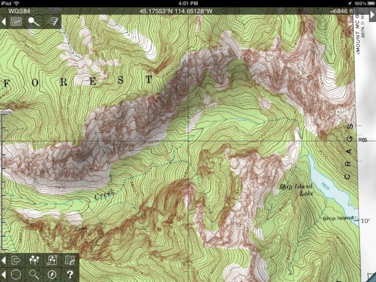
By using USGS 1:24,000 scale topological maps, which are free, Endecott gives you access to more than 69,000 maps that cover the United States and Canada. To use the app, you first zoom into your area of the U.S. or Canada, which will show you a grid. Each grid has a name based on the corresponding USGS map. If you tap and hold the square (the map) of the area you want, you’ll download the map to your iPhone. You’ll want to do this in advance, at home, while you’re on a WiFi connection. Before I go someplace new, I download several maps that surround the area I want to trek through, then I open them up and check them out.
I’ll often augment the Topo Maps app by looking at the area on my Mac or a buddy’s PC with Google Maps in a web browser and/or use the new built-in Apple Maps app on my iPhone. Sometimes I’ll print out a map and sometimes I’ll take a few screenshots to have in my iPhone’s photo library as a backup. While Apple’s version has been taken to task for various urban errors, so far it’s been flawless in the backcountry areas I’ve traveled. In fact, the 3D view lets me zoom into a canyon, then twirl it about, getting a better feel for the steepness of the country and my route.
The Problem with Maps
Maps are only as good as their accuracy. The USGS maps are often old, maybe even 30 or more years old, so they don’t always show newer roads or trails. And some of the old roads and trails require the trained eye of an archeologist to see. Still, the mountains, lakes, rivers, and ridges haven’t moved much in 30 years, so these major landmarks provide you plenty of excellent location data.
At the same time, Endecott’s Topo Maps app will provide you with a little blue dot that shows your current location on the map, via a GPS coordinate. Quite cool and very handy.
As for the flashy photo-based apps you can get on your iPhone or iPad, like Google or Apple’s maps, the problem with these is the currency of the satellite photos. Depending on the time of year and number of years ago when they were taken, you might see a road or you might not, and an open field or clearcut might appear overgrown with trees and bushes when you’re standing next to it in out in the woods. And again, if you’re the kind of person willing to risk getting lost with your iPhone as your only mapping tool, then you just can’t rely on a map app that requires a live data connection to be remotely trustworthy.
Oh, one more thing here: If you’re not particularly backwoods savvy or confident, take a printed map with you every time, along with a dedicated GPS unit worthy of handling drops, dirt, and pouring down rain.
As for me, I tend to place my iPhone 5 into a zip sandwich bag, put it in my front pocket, and go. You can use the iPhone through the bag if you have to, and if I fall in a river, the iPhone will likely survive. The key word here is likely. And your survival, not to mention that of your iPhone, is really all about you, so be smart out there.
How much does the Topo Maps app cost? $7.99 for a version that runs on iPhone, iPad, and iPod. Topo Maps on the iPad shows five times as much map data on the screen, which is great for trip planning and exploring routes from the warmth of your backwoods cabin. There are no ads, just excellent app goodness, and that’s always worth shelling out a few bucks for. So show the man some appreciation and buy the app instead of kludging through the freebies. And besides, when your ass is lost in a field of brush in the middle of nowhere, you’ll appreciate having Topo Maps loaded and ready to roll on your iPhone.
One More Thing: That map screenshot up above? It’s the astounding mess of granite — called the Litner Group — at the end of Ship Island Lake in the middle of Idaho. They are part of the Bighorn Crags, which are part of the Salmon River Mountains. It’s absofreakinglutely one of the best backpacking hikes in Idaho and ranks well with some of the great hikes west of the Rocky Mountains.